4.3
2.1K críticas
Everyone
Calificación de contenido
636.5K
Descargas


Acerca de estas aplicaciones
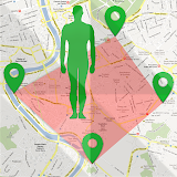
Fingerlator : GPS Area measure descripción
This app even has a lot of options more than other area calculator apps on the store.-The main purpose of the application is to measure area, distance and circumference.
Fingerlator: Area measure is helping for million people measures their fields, mark their needed points
UNIQUE FEATURES:
➜ Draw by finger on map (based on Google Map) in a very smart and flexible way
➜ Quick area/distance marking
➜ Place pins very accurate, and change pins quickly
➜ Name, save, and edit measurements any times
➜ “Undo” button for all actions on the map
➜ GPS tracking Live for walking, driving, running, flying.. around specific boundaries
It also includes a feature to send an auto-generated link to your friends or partners of pinned/selected area, direction, or route - displays the area you want to share.
Get it and start drawing your imagination boundaries today!
Fingerlator: GPS Area Measure is also useful as a map measurement tool for outdoor activities, range finder applications, and sports such as biking or marathon. Comes in handy when exploring golf area or as a golf distance meter, is convenient for land surveys, practical for field pasture area measure, helpful in garden and farm work or planning, great to keep area records. It’s great for construction and agricultural fencing. This application is practical even for solar panel installation, roof area estimation, or trip planning.
Our measuring app has the highest accuracy in the market
Among our users are people constructing roofs, buildings, and roads, farm owners who are spraying, fertilizing, seeding, harvesting farms, or tilling. It’s helpful for biking, traveling, or planning trips. For growing gardens and paddock, grass or lawn - we are the number one choice.
It's a great tool for calculation and measuring.
This is the best solution for farm owners who grow wheat, corn, rapeseed, maize, sugar beet and need to measure the planted area annually.
All in all, it is useful for:
- Farmers, for farm management
- Agronomists
- Town planners
- Construction surveyor
- Landscape artists
- Land-based surveys
- Land record management
- Construction surveys
- Health, Education, and facilities mapping
- Farm fencing
- Sports track measurement
- Construction sites and building sites area
- Asset mapping
- Landscape design
- Facebook :
https://www.facebook.com/app.clstudio.info/
- Youtube :
https://www.youtube.com/channel/UCPfi4XeYX6MF6wQ84JbBVPA/
- Website :
https://clstudio.info/