4.3
28.7K críticas
Everyone
Calificación de contenido
19.7M
Descargas


Acerca de estas aplicaciones
GPS Area Measurements descripción
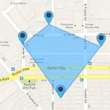
GPS Fields Area Measure is a intelligent app designed to measure area and distance directly on Google Maps. Simply place points on the map and then calculate the area or distance between two specified points. Additionally, you can calculate the total area of any route using the Area Distance Calculator feature.GPS fields area measure proves valuable for accurately calculating GPS area or distance. There are two methods to measure any GPS area or distance. A new feature has been added, known as Points of Interest (POI). This measure app allows users to save and share specific point locations that others may find useful or interesting.
Land measuring app is a smart and efficient tool designed for measuring land distances and areas between two points. Users can accurately measure routes, land, and field areas directly on the maps. It is especially useful for agricultural purposes, allowing users to measure the area and distance of gardens, farms, plots, and more. Simplify your measurements with this intuitive fields area measure application.
Key Features of GPS Fields Area Measure :
1. Accurate Measure field area:
Use GPS technology to measure your field accurately. Just mark your field on the map with GPS points, and the GPS measuring will calculate the area effortlessly.
2. Measure accurate distance:
Get real-time, accurate distance measurements between points with our Area google maps calculator feature. Perfect for planning paths, routes, or outdoor activities.
3. Displays point-to-point distances:
Visualize distances for each line created on the map, providing a comprehensive overview of your measurements with measure GPS.
4. Simple and easy to use:
Our user-friendly interface ensures a seamless experience. Just use points to outline your field, and the land measurement app will handle the calculations effortlessly.
5. Calculate area of land and plots:
Whether it's for farming, construction, or personal curiosity, easily calculate the area of any land or plot using our intuitive land measurement tool.
6. Save and load calculated measurements:
Conveniently save your measurements for future reference and load them when needed. Track your land data with ease.
7. Separate Area and Distance Measuring Units:
Customize your measurements by choosing distinct units for area and distance, providing flexibility and convenience.
8. Easy tools for point management:
Effortlessly create, update, and delete points on the map with our intuitive GPS measuring tool. Add new points with a single tap.
9. Real-time measuring and calculating:
Experience real-time measurement and calculation between two points, enhancing the accuracy of your field measurements.
10. Map, Satellite, Terrain, and Hybrid modes:
Choose from various viewing modes to tailor your map experience based on your preferences.
11. GPS Compass with location:
Benefit from an integrated GPS compass for accurate orientation and location tracking.
Where can you use GPS Fields Area Measure?
- Land-based surveys
- Farm management
- Land record management
- Construction surveys
- Agronomists
- Town planning
- Health, education, and facilities mapping
- Farm fencing
- Sports track measurement
- Construction and building sites
- Asset mapping
- Landscape artists and design
Acreage calculator map challenges of inaccurate and time-consuming land assessment and mapping. Whether you're a land surveyor or planning a field trip, our land area measurement app simplifies measurements, streamlines navigation, and puts all the tools you need at your fingertips.
Give the GPS Fields Area Measure app a try today and discover how easy and convenient it is to measure land area and distance! Download this fantastic GPS distance measure app now to simplify your measurements!